#62 Dr. Tom Casadevall – U.S. Geological Survey

Topic – Preserving and Promoting America’s Geoheritage

Sites of geological significance in the United States are protected at a variety of federal agencies, including the National Park Service, the Bureau of Land Management, and U.S. Forest Service–as well as tribal, state and local entities.

In 2016, U.S. National Academy of Sciences’ National Committee on Geological Sciences established the U.S. Geoheritage and Geoparks Advisory Group to facilitate communication about geoheritage issues at local, national and international levels. The advisory group’s principal aims are to expand the recognition and understanding of geoheritage domestically, and to provide information and advice to local communities as they pursue development of geoheritage areas and geopark-like entities through currently available designations. Through these efforts, as well as national and international presentations, the advisory group works to raise awareness about geoheritage and promote policies to ensure that the United States’ remarkable legacy is protected for future generations.

#61 Jeff Roberts – Colorado Freedom of Information Coalition

Topic – Your Right to Know

You may have heard about a time when hundreds of journalists roamed the Denver metro area, keeping an eye on government — among other things — so that people could stay informed about important stuff, like how their tax dollars are spent. Newspaper journalists have become an endangered species in our state, but that doesn’t mean you can’t find out what’s going on in your community if something isn’t covered in the media. The Colorado Freedom of Information Coalition is a nonprofit, nonpartisan alliance of news organizations, groups and individuals that promotes freedom of the press, open courts and open access to government records and meetings. A big part of CFOIC’s mission is to help journalists and the public understand and use their rights of access to the records and proceedings of state and local government and the judiciary.

#60 Frank Blaha-Professional Engineer, Water Research Foundation

Topic: The Great Influenza Pandemic of 1918

November 2018 is the anniversary of the end of World War I, and it is also the anniversary of the Great Influenza Pandemic, often called the Spanish Flu. While the end of World War I is considered an historic event in our history, the 1918 Influenza Pandemic is practically forgotten.

Numbers alone tell a compelling story for the flu being a critical event for humanity. The typical estimates are that approximately 20 million people were killed by World War I over a four-year period, while 50 to 100 million people were killed by the flu–with most of those deaths occurring over a four-month period.

This presentation will shine briefly on the Great Influenza, the important intertwining of the flu with World War I, freedom of speech, and local impacts of and responses to the flu. The flu should be much better remembered, given its impact on humanity.

#59 Jim Reed – RockWare Inc. Director of Research and Development

Topic: Applying Geological Exploration Methods to Assist Homicide Investigators in Locating Clandestine Graves

In 1988, NecroSearch International, a non-profit organization, was founded to provide the international law enforcement community with scientific assistance in locating clandestine gravesites related to homicides. Thirty years later, NecroSearch has assisted police and district attorneys with more than 300 cases in 40 states on 4 continents. Jim’s presentation will describe how the multi-disciplinary expertise of NecroSearch volunteer with expertise in anthropology, botany, criminalistics, entomology, geology, geophysics, meteorology, psychology and other disciplines have been applied towards solving crimes.

#58 Joseph Kerski – Environmental Systems Research Institute

Title:  Good Maps, Bad Maps, Location Privacy, and Why It All Matters

Description: Mapping and cartography is an ancient art and science, but maps are more relevant and more numerous than ever before. The advent of web based Geographic Information Systems (GIS) has enabled anyone and everyone to make maps and share personal information such as their location. Join Geographer Joseph Kerski as we discuss how you can be a critical consumer of maps, how to make your own maps, and why mapping issues such as location privacy are increasingly relevant.

#57 – Dr. Mike Bell – Using Science to Influence Management of our National Parks

The National Park Service manages 417 units across the United States to preserve natural and cultural resources, and the values of our great nation. From grizzly bears to grizzled peaks and charges to early American history, these units represent some of the most unique places on earth. But as climate change, air pollution and invasive species impact the health of parks, managers must adapt to a new normal in order to preserve the integrity of the ecosystem for future generations.

#56 – Erin McDanal – Responses to Drought by Colorado’s Governors

In large part the history of Colorado is the history of its water use. From at least 1200 A.D. to the current period, the region now known as Colorado has depended on its access to water to support civilization. It hasn’t been easy managing water within an arid and drought-prone region. Many scientists believe that climate change will only stretch the limits of our state’s water supply as Colorado’s population grows, making drought a significant issue in the future as it has been in the past. Erin’s talk will focus on the responses to drought by the governors of Colorado during the development of the state.

Speaker’s Bio:

Erin McDanal - Colorado State ArchivistErin McDanal is a native Coloradan, living here since the early 1950s. She has been an historian and archivist since 1977, with her most “important” claim to fame as co-author of How the Waste Was Won, a history of the Fort Collins sewer system. She worked as an historian, doing public history-type projects and since 1990 has worked at the Colorado State Archives as an archivist. After retiring in 2011, she returned to work on a part-time basis as a water archivist, cataloging the huge amount of records pertaining to water in the Archives. The governors’ collections proved especially interesting, as they shed light on the development of Colorado through its water history. She hopes to spread the word about the Colorado State Archives and the 100,000 cubic feet of state records deposited there.

#55 – Dr. Carla Klehm – From My Coolest Archaeological Find in Africa to Why Wakanda from Marvel’s Black Panther Movie is (Almost) a Real Place

Dr. Carla Klehm, Assistant Professor Adjunct at University of Colorado Boulder

Topic – From My Coolest Archaeological Find in Africa to Why Wakanda from Marvel’s Black Panther Movie is (Almost) a Real Place

Just how two giraffes got to China from Africa nearly 80 years before Columbus first visited the Americas is one of many delightful examples of Africa’s long-standing connections to other continents. With the longest record of human history on the globe, Africa offers many surprising stories about which we don’t often hear.

Dr. Carla Klehm’s work as an archaeologist focuses on investigating stories of cultures in contact long before Europeans arrived—in particular, the precolonial kingdoms and states in southern Africa that traded gold and ivory with the Middle East, India and China.

Carla will share stories likely to shift one’s view of the history of sub-Saharan Africa, along with discoveries revealing that Black Panther’s Wakanda is not that far from reality. She also will explain some of the science behind the scenes—from utilizing satellite imagery to “predict” where archaeological sites are located to chemically analyzing glass to source objects from around the world.

Speaker Bio

Dr. Carla Klehm is Assistant Professor Adjunct at University of Colorado Boulder, having received her PhD in Anthropology from University of Texas at Austin in 2013. She has taught about archaeology and Africa at University of Texas at Austin, Washington University in St. Louis, and University of Denver.

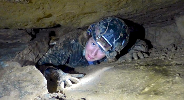
Originally a historian and a (failed) pre-med student, Carla found archaeology after merging her love for history and stories with her strengths in quantitative methods. After her first dig in Hungary made her realize she also could travel and be outside for her job, she was sold.

Carla has worked in Africa since 2007, and currently directs a multinational project in Botswana near the Kalahari Desert in southern Africa, supported by the National Science Foundation, National Endowment for the Humanities, National Geographic Society and others. Her research in Botswana investigates questions about the emergence of inequality, urbanization and climate change as the Africa interior is linked through trade to the Middle East and Asia before the arrival of Europeans (ca. 500-1500 AD).

She also has worked in Ethiopia on early human migrations 100,000 years ago out of Africa, in Kenya on 5,000 year-end megalithic monuments, and across Africa on issues of museums and conservation. For a quick and fun read on some of her research, check out theappendix.net/issues/2014/1/trade-tales-and-tiny-trails-glass-beads-in-the-kalahari-desert

#54 – Johanna Kovarik – A Life Underground: Studying and Stewarding the Magical Subterranean World of Caves

Johanna Kovarik speaks on caving for Golden Beer Talks - Golden ColoradoMay 8, 2018
Johanna Kovarik, U.S.Forest Service, National Cave and Karst Program Coordinator

Topic – A Life Underground: Studying and Stewarding the Magical Subterranean World of Caves

Caves and karst landscapes are rich in resources, including the largest springs around the world and the most productive groundwater on Earth. Caves and karst provide a unique subsurface habitat for rare animals. Caves preserve fragile archaeological and paleontological materials for millennia. Throughout history people have used caves for many purposes, from tourism to farming to protection. A growing number of scientists are heading underground to study what caves can offer us as a record of our planet’s past conditions, a home for some of the most fascinating microbes, and in many places the source of our water. It all begins with mapping these caves – the true exploration of these subsurface ecosystems. Learn more about how caves form, how they impact our everyday lives, and travel around the subterranean world with Johanna Kovarik through images and stories of these fantastic places.

Speaker Bio
Johanna Kovarik has been studying and working in caves since she got her first job with the National Park Service in Carlsbad Caverns, New Mexico in 2003. She went on to earn her Masters in Geoscience from Western Kentucky University, and her Ph.D. from the School of Geosciences at the University of South Florida. Her research work is primarily in land use and watershed dynamics, groundwater vulnerability, human disturbance, and natural resource management. In 2014 Johanna was made a Fellow of the National Speleological Society, and she has led and participated in grant-funded cave expeditions around the world as a geoscientist, cave surveyor, and cartographer. She has served for the past six years as the National Cave and Karst Program Lead for the U.S. Forest Service, moving into this role from her work as a geologist and hydrologist on the Tongass National Forest in southeast Alaska from 2004 to 2011. She has also led the National Groundwater Program and managed the GeoCorps internship program for the agency. From 2010 to 2015 she led a multi-faceted project in southern Mexico with the Forest Service’s Office of International Programs, and in 2015 she was awarded the National Rise to the Future: Friend of Fish and Watershed Award from the U.S. Forest Service for her national and international work with karst watersheds. Her latest project was creating and producing an educational program called CavesLIVE on caves and karst, with a 40 minute pre-taped program and a LIVE Q&A program streamed from Blanchard Springs Caverns in Virginia this past March. To learn more, visit www.CavesLIVE.org.

#53 – Catherine Costello – Mapping & Tracking Wildland Fires

March 13, 2018
Cartographer Catherine Costello – usgs

Topic – Mapping & Tracking Wildland Fires

The Geospatial Multi-Agency Coordination (GeoMAC) app is an internet-based mapping application originally designed for fire managers to access online mapping of locations and perimeters for wildland fires burning in the United States. With a standard web browser, GeoMAC allows fire personnel to view and pinpoint affected areas. With growing concern over western wildland fires, the app became available to the public in 2000. Today, GeoMAC is the primary source for all wildland fire perimeters, and in 2017 the app—including website and data services—received almost 1 billion hits.

Speaker Bio

Catherine Costello-USGS at Golden Beer Talks - Golden ColoradoCatherine Costello has been a cartographer with the United States Geological Survey (USGS) for 31 years. Much of her career has revolved around natural hazards. She worked as a GIS (Geographic Information System) specialist during Hurricane Katrina, drove a truck delivering fire fighting supplies for two summers, collaborated with FEMA (Federal Emergency Managemet Agency) on food and landslide hazard maps. Costello recently became the project lead for the GeoMAC group.

She has a B.S. in Geography from Utah State University, and an M.S in GIS from the University of Denver.